
Ardara Guidebook for location
City/town information
Beautiful town with lots of site seeing attractions. Great places to eat and drink.
Ardara (Irish: “Ard an Rátha” meaning “Height of the Fort” – pronounced “Ardra”) is a small town in County Donegal, Ireland, located along the N56 road.
Some of the main scenic points near the town are the Glengesh Pass, the Maghera Caves and Waterfall, and the views out over the Atlantic from Loughros Point.
Ardara is a vibrant and bustling town which is very popular with holidaymakers.
25 Recomendado por los habitantes de la zona
Ardara
Beautiful town with lots of site seeing attractions. Great places to eat and drink.
Ardara (Irish: “Ard an Rátha” meaning “Height of the Fort” – pronounced “Ardra”) is a small town in County Donegal, Ireland, located along the N56 road.
Some of the main scenic points near the town are the Glengesh Pass, the Maghera Caves and Waterfall, and the views out over the Atlantic from Loughros Point.
Ardara is a vibrant and bustling town which is very popular with holidaymakers.
Sightseeing
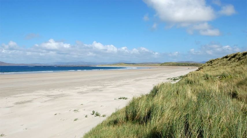
Portnoo beach is a must attraction. Golden sands for miles
20 Recomendado por los habitantes de la zona
Portnoo
Portnoo beach is a must attraction. Golden sands for miles
Unbelievable Waterfall within 10mins drive from our house. A must see when visiting.
40 Recomendado por los habitantes de la zona
Assaranca Waterfall
Unbelievable Waterfall within 10mins drive from our house. A must see when visiting.
Killybegs is a town in County Donegal, Ireland.
It is the largest fishing port in the country and on the island of Ireland. It is located on the south coast of the county, north of Donegal Bay, near Donegal Town.
Its Irish name Na Cealla Beaga means 'little cells', a reference to early monastic settlements.
27 Recomendado por los habitantes de la zona
Killybegs
Killybegs is a town in County Donegal, Ireland.
It is the largest fishing port in the country and on the island of Ireland. It is located on the south coast of the county, north of Donegal Bay, near Donegal Town.
Its Irish name Na Cealla Beaga means 'little cells', a reference to early monastic settlements.
One kilometer from Assaranca Waterfall, the Maghera Caves are located beneath Slievetooey mountain and some are accessible at low tides from Maghera Strand.
Maghera Beach stretches out into the bay (please be careful of tides and strong currents, and check locally regarding times). Access to the beach is via a car park and a short 200 metre walk to the caves.
There are over 20 caves, 8 arches and 5 tunnels which can be visited, ideally by Kayak or other small craft, and would be enough to sate the appetite of any explorer.
16 Recomendado por los habitantes de la zona
Caves of Maghera
One kilometer from Assaranca Waterfall, the Maghera Caves are located beneath Slievetooey mountain and some are accessible at low tides from Maghera Strand.
Maghera Beach stretches out into the bay (please be careful of tides and strong currents, and check locally regarding times). Access to the beach is via a car park and a short 200 metre walk to the caves.
There are over 20 caves, 8 arches and 5 tunnels which can be visited, ideally by Kayak or other small craft, and would be enough to sate the appetite of any explorer.
Doon Fort is undoubtedly one of the most spectacularly picturesque heritage sites in Ireland. It is situated on a small island in the middle of Loughadoon, just outside the charming village of Ardara in County Donegal.
Doon FortDoon Fort is a large drystone fort, thought to be the residence of the O’Boyle Chieftains. The exact date of the construction of the fort is unknown and it may date from the late Iron Age to Early Medieval times. The fort has been linked first with the Breslin clan who were said to have occupied it from the 5th century onwards. It was later associated with the O’ Boyle clan before it fell into disrepair. These forts were used as royal residences and as status symbols. Doon Fort is classified as a Western Stone Fort which are characterised as having thick high stone enclosing walls.
In 1954, a programme of restoration work was undertaken on the fort by the Bord Fáilte to prevent the site from disappearing. Today, sections of the wall are beginning to collapse due to growth of ivy and other factors. The Ardara GAP Heritage and History Group was formed to highlight the significance of the site and to help to preserve this site for future generations.
Doon Fort
Doon Fort is undoubtedly one of the most spectacularly picturesque heritage sites in Ireland. It is situated on a small island in the middle of Loughadoon, just outside the charming village of Ardara in County Donegal.
Doon FortDoon Fort is a large drystone fort, thought to be the residence of the O’Boyle Chieftains. The exact date of the construction of the fort is unknown and it may date from the late Iron Age to Early Medieval times. The fort has been linked first with the Breslin clan who were said to have occupied it from the 5th century onwards. It was later associated with the O’ Boyle clan before it fell into disrepair. These forts were used as royal residences and as status symbols. Doon Fort is classified as a Western Stone Fort which are characterised as having thick high stone enclosing walls.
In 1954, a programme of restoration work was undertaken on the fort by the Bord Fáilte to prevent the site from disappearing. Today, sections of the wall are beginning to collapse due to growth of ivy and other factors. The Ardara GAP Heritage and History Group was formed to highlight the significance of the site and to help to preserve this site for future generations.
The blue flag beach is 1.5 km in length, courting the Championship Golf Course of Narin and Portnoo Golf Club. The beach offers safe bathing, and at its terminus is the stone outcrop of Carraigfad (Long Rock). For the more adventurous walker, a swift trip across these rocks and along the edge of the golf course will take you to another quieter beach of 1 km in length, where (if you’re lucky), you’ll see some basking seals at the entrance to the Gweebarra bay at Cashelgolan point.
11 Recomendado por los habitantes de la zona
An Fhearthainn
The blue flag beach is 1.5 km in length, courting the Championship Golf Course of Narin and Portnoo Golf Club. The beach offers safe bathing, and at its terminus is the stone outcrop of Carraigfad (Long Rock). For the more adventurous walker, a swift trip across these rocks and along the edge of the golf course will take you to another quieter beach of 1 km in length, where (if you’re lucky), you’ll see some basking seals at the entrance to the Gweebarra bay at Cashelgolan point.
Food scene
Mickalene's
Main StreetAmazing food and staff, highly recommend.
Charlie's West End Cafe
5 Main StGreat spot for lunch
Nancy's
Front Streetgreat for seafood, great specials
Check out the "FISH SHAK" beside the harbour. It serves the best fish and chips in Ireland
27 Recomendado por los habitantes de la zona
Killybegs
Check out the "FISH SHAK" beside the harbour. It serves the best fish and chips in Ireland
Great spot for lunch and also sample amazing home made cakes and coffee
10 Recomendado por los habitantes de la zona
Sheila's Coffee and Cream
Great spot for lunch and also sample amazing home made cakes and coffee